Mysterious 'Landlocked Lips' Hill in Sudan Sparks Research Interest
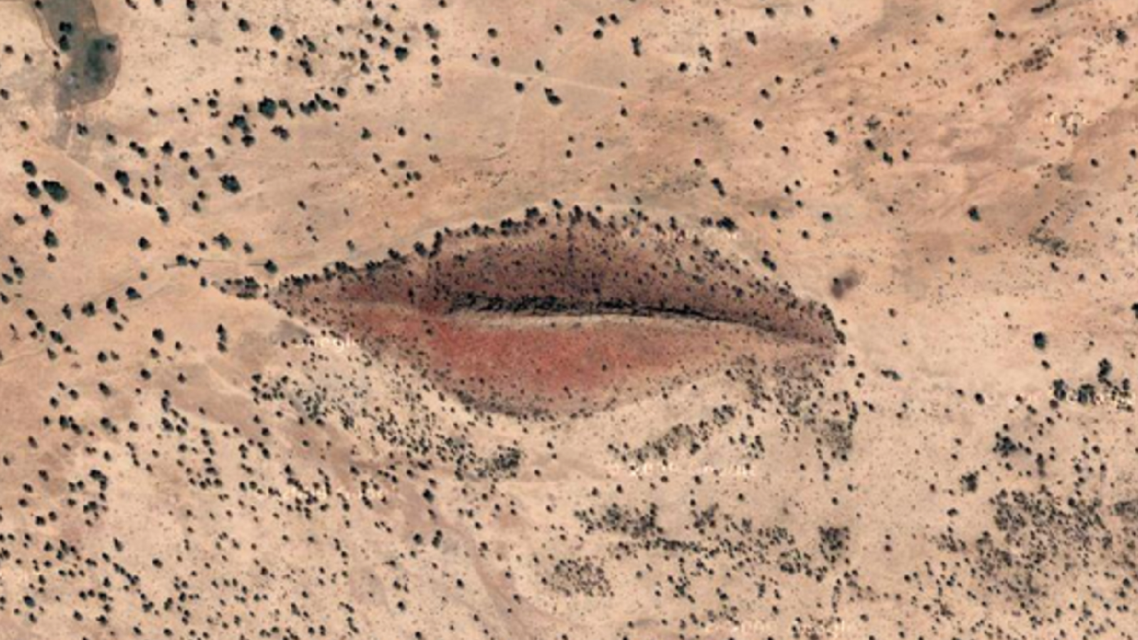
An unusually shaped hill in Sudan, affectionately dubbed the "Landlocked Lips," is enveloped in intrigue and poses questions to researchers about its formation. This striking geographical feature has caught the attention of experts who are eager to understand how such a peculiar hill could come to exist.
QUICK FACTS
Where is it? West Darfur, Sudan [12.370771816, 23.322227802]
What’s in the photo? A hill shaped like human lips
Where did the photo originate? Google Earth
When was it taken? 2012
Captured by Google Earth satellites in 2012, this fascinating satellite photo reveals a hill formation in Sudan that strikingly resembles pursed human lips, as if blowing a kiss into the cosmos. This quirky resemblance has sparked curiosity among geologists and casual observers alike, leading to a deeper investigation into this geographical oddity.
The hill measures approximately 3,000 feet (900 meters) in length and 1,200 feet (350 meters) at its widest point. Nestled in Sudan's West Darfur state, it is located about 60 miles (95 kilometers) east of the Chad border, surrounded by agricultural fields that paint a picture of life in the arid region. Satellite imagery from 2012 reveals that the ground around the hill has been ravaged by drought, resulting in a parched landscape that emphasizes the hill's unique shape, which is further accentuated by a pinkish hue on its slopes.
However, more recent images indicate a remarkable transformation. Nowadays, both the hill and its surrounding environment appear lush and green, teeming with vegetation, a stark contrast to the previous desolation. This change indicates the area's potential for regeneration and a shift in ecological conditions, although the precise timeline for these changes remains unclear.
Currently, the hill does not have an official name, yet it is informally referred to as the "Landlocked Lips" campground on Google Maps, though it's uncertain if any actual camping facilities are present in the vicinity.
Experts have begun to theorize about the hill's origins based on the available satellite imagery. According to Josh Roering, a geomorphologist at the University of Oregon who specializes in landscape dynamics, there’s a possibility that a narrow unit of exposed rock runs through the center of the formation. "It looks like there's a dike or narrow unit of resistant rock running through the middle of that ridgeline that erodes more slowly than the surrounding rock and thus sticks out," Roering explained in an email to Live Science.
Dikes are significant geological features that cut through larger horizontal rock formations. These structures can result from a variety of geological processes, including volcanic activity and tectonic shifts, but they can also arise from sedimentary processes. Despite these insights, the exact nature of the dike that may be present in this hill remains uncertain.
Roering elaborated, stating, "If correct, the shape and extent of that resistant rock unit thus sets the scale of the feature as the less resistant surrounding rock forms sloping terrain on either side." Interestingly, similar geological formations can be found in places such as the deserts of New Mexico and the Mackenzie dike swarm in Yukon, Canada, highlighting how diverse geological formations can be across different regions.
However, Roering cautioned that, without the ability to study the formation up close, these ideas remain speculative. The charm of the "Landlocked Lips" lies not only in its peculiar visual representation but also in the geological mysteries it conceals.